Area 51 is a remote tract of land in the southwestern portion of southern Nevada in the western United States. Situated at its center, on the southern shore of Groom Lake, a dry lakebed (salt lake), is a large military airfield, one of the most secretive places in the world. The base's primary purpose is to support development and testing of experimental aircraft and weapons systems.[1][2]
The base lies within the United States Air Force's vast Nevada Test and Training Range. Although the facilities at the range are managed by the 99th Air Base Wing at Nellis Air Force Base, the Groom facility appears to be run as an adjunct of the Air Force Flight Test Center (AFFTC) at Edwards Air Force Base in the Mojave Desert, around 160 miles (260 km) from Groom (AFFTC homepage), and as such the base is known as Air Force Flight Test Center (Detachment 3).[3][4]
Other names used for the facility include Dreamland, Paradise Ranch,[5] Home Base, Watertown Strip, Groom Lake[6] and most recently Homey Airport.[7] The area is part of the Nellis Military Operations Area, and military pilots refer to the forbidden airspace around it (R-4808N[8]) as The Box.
The intense secrecy surrounding the base, the very existence of which the U.S. government barely acknowledges, has led it to become the frequent subject of conspiracy theories and UFO folklore.
Geography

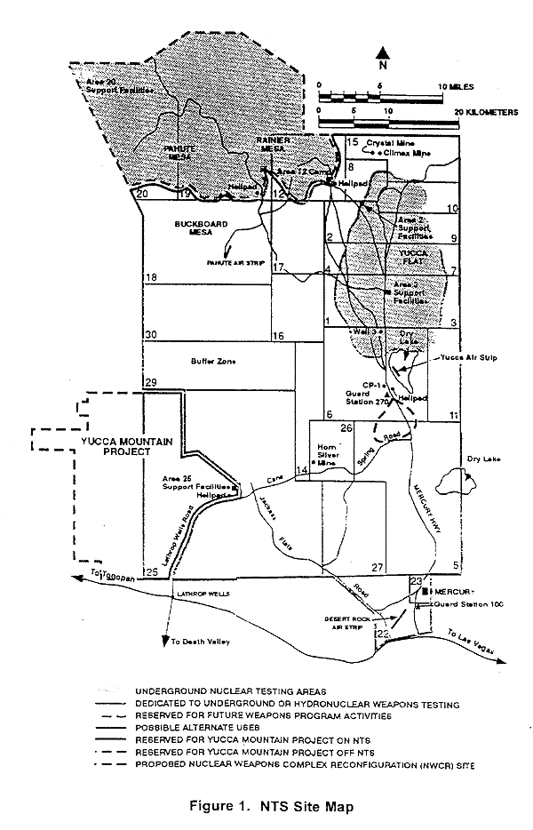
Area 51 shares a border with the Yucca Flat region of the Nevada Test Site (NTS), the location of 739 of the 928 nuclear tests conducted by the United States Department of Energy at NTS.[9] The Yucca Mountain nuclear storage facility is approximately 40 miles (64 km) southwest of Groom Lake.
The designation "Area 51" is contentious, appearing on older maps of the NTS but not newer ones[citation needed], yet the same naming scheme is used for other parts of the Nevada Test Site.[10][11]
The area is connected to the internal NTS road network, with paved roads leading south to Mercury and west to Yucca Flat. Leading northeast from the lake, the wide and well-maintained Groom Lake Road runs through a pass in the Jumbled Hills. The road formerly led to mines in the Groom basin, but has been improved since their closure. Its winding course runs past a security checkpoint, but the restricted area around the base extends further east. After leaving the restricted area, Groom Lake Road descends eastward to the floor of the Tikaboo Valley, passing the dirt-road entrances to several small ranches, before converging with State Route 375, the "Extraterrestrial Highway", south of Rachel.
Operations at Groom Lake

Groom Lake is not a conventional airbase, as frontline units are not normally deployed there. It instead appears to be used during the development, testing, and training phases for new aircraft. Once these aircraft have been approved by the United States Air Force or other agencies such as the CIA, operation of that aircraft is generally conducted from a normal air force base. Groom is reported, however, to be the permanent home for a small number of Soviet-designed aircraft[12] which are analyzed and used for training purposes.
Soviet spy satellites obtained photographs of the Groom Lake area during the height of the Cold War, and later civilian satellites produced detailed images of the base and its surroundings. These images support only modest conclusions about the base; they depict a nondescript base, long airstrip, hangars and the lake, but nothing that supports some of the claims about underground facilities.
Though no ICAO identifier for the base appears on any official document, in December 2007, airline pilots noticed that the base had appeared in their aircraft navigation systems' latest Jeppesen database revision as "KXTA".[13]
U-2 program
Groom Lake was used for bombing and artillery practice during World War II, but was then abandoned until 1955, when it was selected by Lockheed's Skunk Works team as the ideal location to test the forthcoming U-2 spy plane.[14] The lakebed made an ideal strip from which they could operate the troublesome test aircraft, and the Emigrant Valley's mountain ranges and the NTS perimeter protected the test site from prying eyes and outside interference.
Lockheed constructed a makeshift base at Groom, consisting of little more than a few shelters, workshops and trailer homes in which to house its small team. The first U-2 flew at Groom in August 1955, and U-2s under the control of the CIA began overflights of Soviet territory by mid-1956.
During this period, the NTS continued to perform a series of atmospheric nuclear explosions. U-2 operations throughout 1957 were frequently disrupted by the Plumbbob series of atomic tests, which detonated over two-dozen devices at the NTS. The Plumbbob-Hood explosion on July 5 scattered fallout across Groom and forced a temporary evacuation.
Blackbird programs

Even before U-2 development was complete, Lockheed began work on its successor, the CIA's OXCART project, a Mach-3 high altitude reconnaissance aircraft, a later variant of which became the famed USAF SR-71 Blackbird. The Blackbird's flight characteristics and maintenance requirements forced a massive expansion of facilities and runways at Groom Lake. By the time the first A-12 Blackbird prototype flew at Groom in 1962, the main runway had been lengthened to 8,500 ft (2,600 m), and the base boasted a complement of over 1,000 personnel. It had fueling tanks, a control tower, and a baseball diamond. Security was greatly enhanced, the small civilian mine in the Groom basin was closed, and the area surrounding the valley was made an exclusive military preserve. Groom saw the first flight of all major Blackbird variants: A-12, SR-71, the abortive YF-12 interceptor variant, and the D-21 Blackbird-based drone project. The A-12 would remain at Groom Lake until 1968.
Have Blue/F-117 program
The Lockheed Have Blue prototype stealth fighter (a smaller cousin of the F-117 Nighthawk) first flew at Groom in December 1977.[15] Testing of a series of ultra-secret prototypes continued there until mid-1981, when testing transitioned to the initial production of F-117 stealth fighters. In addition to flight-testing, Groom performed radar profiling, F-117 weapons testing, and was the location for training of the first group of frontline USAF F-117 pilots. Subsequently, the still highly classified active-service F-117 operations moved to the nearby Tonopah Test Range, and finally to Holloman Air Force Base.
Later operations
| | This section needs additional citations for verification. Please help improve this article by adding reliable references. Unsourced material may be challenged and removed. (July 2008) |

Since the F-117 became operational in 1983, operations at Groom Lake have continued unabated. The base and its associated runway system have been expanded, and daily flights bringing civilian commuters from Las Vegas continue. Some commentators, after examining recent satellite photos of the base, estimate it to have a live-in complement of over 1,000 people, with a similar number commuting from Las Vegas. In 1995, the federal government expanded the exclusionary area around the base to include nearby mountains that had hitherto afforded the only decent overlook of the base. Subsequently, limited views of the area are available only from the summits of several distant mountains east.
Aircraft that have been tested at Groom include the Northrop Tacit Blue stealth demonstrator, various classified UAVs, and a stealthy cruise missile (most likely the AGM-129 Advanced Cruise Missile). Other rumored Groom test programs include a small stealthy VTOL troop-transport aircraft, the Aurora hypersonic spy plane, a "Stealth Blimp", a secret USAF spaceplane codenamed Blackstar,[16] and replacements for the SR-71 and F-117A.
Area 51 commuters
Defense contractor EG&G maintains a private terminal 36°05′31″N 115°09′54″W / 36.092, -115.165 at McCarran International Airport in the Las Vegas metropolitan area. A number of unmarked aircraft operate daily shuttle services from McCarran to sites operated by EG&G in the extensive federally controlled lands in southern Nevada. These aircraft reportedly use JANET radio call signs (e.g., "JANET 6") (the JANET airplanes are now using either call sign "Bland" or "JANET" on the radio, and "WWW" on their flight number identifier), said to be an acronym for "Joint Air Network for Employee Transportation" or (perhaps jokingly) "Just Another Non-Existent Terminal". EG&G advertises in the Las Vegas press for experienced military pilots, requiring applicants to be eligible for government security clearance, and that successful applicants can expect to always stay overnight at Las Vegas. These aircraft, painted white with red trim (the livery of now defunct Western Airlines), include six Boeing 737/T-43As and several smaller turboprops. Their tail numbers are registered to the U.S. Air Force. They are reported to shuttle to Groom, Tonopah Test Range, to other locations in the NAFR and NTS, and reportedly to Naval Air Weapons Station China Lake. Observers tracking the number of departures and cars in the private EG&G parking lot at McCarran estimate several thousand JANET commuters each day. These shuttle flights were previously operated by Key Air, which had flown 22,000 passenger trips on 300 flights from Nellis Air Force Base to Tonopah Test Range per month from 1982 until early 1991.[citation needed]

Commuter service is provided along Groom Lake Road by a bus, catering to a small number of employees living in several small communities beyond the NTS boundary (although it is not clear whether these workers are employed at Groom or at other facilities in the NTS). The bus travels Groom Lake Road and stops at Crystal Springs, Ash Springs, and Alamo, and parks at the Alamo courthouse overnight.
Runways
The airbase, given the ICAO airport identifier code of KXTA and listed as "Homey Airport"[17] in aviation GPS databases, has seven runways including one that now appears to be closed. The closed runway, 14R/32L, is also by far the longest with a total length of approximately 7,093 meters (23,270 feet), not including stopway. The other runways are two asphalt runways, the 14L/32R with a length of 3,658 meters (12,000 feet) and 12/30 with a length of 1,652 meters (5,420 feet), and four runways located on the salt lake. These four runways are 09L/27R and 09R/27L, which are both approximately 3,489 meters (11,440 feet), and 03L/21R and 03R/21L, which are both approximately 3,057 meters (10,030 feet).[18][19]
U.S. government's positions on Area 51

On July 14, 2003 the Federal Government admitted the facility's existence, tacitly conceding that the Air Force has an "operating location" near the lake, but does not provide any further information. The base is conspicuously absent from Federal publications and inquiries to the government regarding the facility are rejected for reasons of national security.[citation needed]
Unlike much of the Nellis range, the area surrounding the lake is permanently off-limits both to civilian and normal military air traffic. Radar stations protect the area, and unauthorized personnel are quickly expelled. Even military pilots training in the NAFR risk disciplinary action if they accidentally stray into the exclusionary "box" surrounding Groom's airspace.[20]

Perimeter security is provided by uniformed private security guards working for EG&G's security subcontractor Wackenhut,[21] who patrol in desert camouflage Jeep Cherokees and HMMWV vehicles, and more recently, champagne-colored Ford F-150 pickups and gray Chevy 2500 4X4 pickups. Although the guards are armed with M16s, no violent encounters with Area 51 observers have been reported; instead, the guards generally follow visitors near the perimeter and radio for the Lincoln County Sheriff. Deadly force is authorized if violators who attempt to breach the secured area fail to heed warnings to halt. Fines of around $600 seem to be the normal course of action, although some visitors and journalists report receiving follow-up visits from FBI agents. Some observers have been detained on public land for pointing camera equipment at the base. Surveillance is supplemented using buried motion sensors[22][23][24] and by HH-60 Pave Hawk helicopters.
The base does not appear on public U.S. government maps;[25] the USGS topographic map for the area only shows the long-disused Groom Mine,[26] and the civil aviation chart for Nevada shows a large restricted area,[27] but defines it as part of the Nellis restricted airspace. Similarly the National Atlas page showing federal lands in Nevada[28] does not distinguish between the Groom block and other parts of the Nellis range. Although officially declassified, the original film taken by U.S. Corona spy satellite in the 1960s has been altered prior to declassification; in answer to freedom of information queries, the government responds that these exposures (which map to Groom and the entire NAFR) appear to have been destroyed.[29] Terra satellite images (which were publicly available) were removed from web servers (including Microsoft's "Terraserver") in 2004,[30] and from the monochrome 1 m resolution USGS data dump made publicly available. NASA Landsat 7 images are still available (these are used in the NASA World Wind). Higher resolution (and more recent) images from other satellite imagery providers (including Russian providers and the IKONOS) are commercially available. These show, in considerable detail, the runway marking, base facilities, aircraft, and vehicles.
Nevada's state government, recognizing the folklore surrounding the base might afford the otherwise neglected area some tourism potential, officially renamed the section of State Route 375 near Area 51 "The Extraterrestrial Highway", and posted fancifully illustrated signs along its length.[31]
Although federal property within the base is exempt from state and local taxes, facilities owned by private contractors are not. Area 51 researcher Glenn Campbell claimed in 1994 that the base only declares a taxable value of $2 million to the Lincoln County tax assessor, who is unable to enter the area to perform an assessment.[32]
Environmental lawsuit
In 1994, five unnamed civilian contractors and the widows of contractors Walter Kasza and Robert Frost sued the USAF and the United States Environmental Protection Agency. Their suit, in which they were represented by George Washington University law professor Jonathan Turley, alleged they had been present when large quantities of unknown chemicals had been burned in open pits and trenches at Groom. Biopsies taken from the complainants were analyzed by Rutgers University biochemists, who found high levels of dioxin, dibenzofuran, and trichloroethylene in their body fat. The complainants alleged they had sustained skin, liver, and respiratory injuries due to their work at Groom, and that this had contributed to the deaths of Frost and Kasza. The suit sought compensation for the injuries they had sustained, claiming the USAF had illegally handled toxic materials, and that the EPA had failed in its duty to enforce the Resource Conservation and Recovery Act (which governs handling of dangerous materials). They also sought detailed information about the chemicals to which they were allegedly exposed, hoping this would facilitate the medical treatment of survivors. Congressman Lee H. Hamilton, former chairman of the House Intelligence Committee, told 60 Minutes reporter Leslie Stahl, "The Air Force is classifying all information about Area 51 in order to protect themselves from a lawsuit."[33]
Citing the State Secrets Privilege, the government petitioned trial judge U.S. District Judge Philip Pro (of the United States District Court for the District of Nevada in Las Vegas) to disallow disclosure of classified documents or examination of secret witnesses, alleging this would expose classified information and threaten national security.[34] When Judge Pro rejected the government's argument, President Bill Clinton issued a Presidential Determination, exempting what it called, "The Air Force's Operating Location Near Groom Lake, Nevada" from environmental disclosure laws. Consequently, Pro dismissed the suit due to lack of evidence. Turley appealed to the U.S. Court of Appeals for the Ninth Circuit, on the grounds that the government was abusing its power to classify material. Secretary of the Air Force Sheila E. Widnall filed a brief that stated that disclosures of the materials present in the air and water near Groom "can reveal military operational capabilities or the nature and scope of classified operations." The Ninth Circuit rejected Turley's appeal,[35] and the U.S. Supreme Court refused to hear it, putting an end to the complainants' case.
The President continues to annually issue a determination continuing the Groom exception.[36][37][38] This, and similarly tacit wording used in other government communications, is the only formal recognition the U.S. Government has ever given that Groom Lake is more than simply another part of the Nellis complex.
An unclassified memo on the safe handling of F117 material was posted on an Air Force website in 2005. This discussed the same materials for which the complainants had requested information (information the government had claimed was classified). The memo was removed shortly after journalists became aware of it.[39]
1974 Skylab photography
In January 2006, space historian Dwayne A. Day published an article in online aerospace magazine The Space Review titled "Astronauts and Area 51: the Skylab Incident." The article was based around a recently declassified memo written in 1974 to CIA director William Colby by an unknown CIA official. The memo reported that astronauts on board Skylab 4 had, as part of a larger program, inadvertently photographed a location of which the memo said "There were specific instructions not to do this.
The memo details debate between federal agencies regarding whether the images should be classified, with Department of Defense agencies arguing that it should, and NASA and the State Department arguing against classification. The memo itself questions the legality of unclassified images to be retroactively classified.
Remarks on the memo,[42] handwritten apparently by DCI (Director of Central Intelligence) Colby himself, read:
- He did raise it - said State Dept. people felt strongly. But he inclined leave decision to me (DCI) - I confessed some question over need to protect since:
- USSR has it from own sats
- What really does it reveal?
- If exposed, don't we just say classified USAF work is done there?
The declassified documents do not disclose the outcome of discussions regarding the Skylab imagery, but were not placed in the federal government's archive of satellite imagery along with the remaining Skylab 4 photographs.
UFO and other conspiracy theories concerning Area 51
Its secretive nature and undoubted connection to classified aircraft research, together with reports of unusual phenomena, have led Area 51 to become a focus of modern UFO and conspiracy theories. Some of the activities mentioned in such theories at Area 51 include:
- The storage, examination, and reverse engineering of crashed alien spacecraft (including material supposedly recovered at Roswell), the study of their occupants (living and dead), and the manufacture of aircraft based on alien technology.
- Meetings or joint undertakings with extraterrestrials.
- The development of exotic energy weapons (for SDI applications or otherwise) or means of weather control.
- The development of time travel and teleportation technology.
- The development of unusual and exotic propulsion systems related to the Aurora Program (see Aurora aircraft).
- Activities related to a supposed shadowy one world government and or the Majestic Twelve organization.
Many of the hypotheses concern underground facilities at Groom or at nearby Papoose Lake, and include claims of a transcontinental underground railroad system, a disappearing airstrip (nicknamed the "Cheshire Airstrip", after Lewis Carroll's Cheshire cat) which briefly appears when water is sprayed onto its camouflaged asphalt,[43] and engineering based on alien technology. In 1989, Bob Lazar claimed that he had worked at a facility at Papoose Lake (which he called S-4) on such a U.S. Government flying saucer.
An editor at www.abovetopsecret.com claimed in 2004 that, during the mid 1990s, the most secret work previously done at Groom was quietly moved to other facilities, including Dugway Proving Ground in Utah, and that the continued secrecy around Groom is largely a successful attempt at misdirection.[44]
The 1996 documentary Dreamland directed by Bruce Burgess included an interview with a 71 year old mechanical engineer who claimed to be a former employee at Area 51 during the 1950s, working on a "flying disc simulator" built to train US Pilots, based on a disc originating from a crashed extraterrestrial craft. During his career at Area 51 he claimed to have worked with an extraterrestrial being whose name was "J-Rod", described as a telepathic translator.[45]
Dan Burisch (real name, Dan Crain) claims to have worked on cloning alien viruses at Area 51, also with the alien "J-Rod".[46][47]
In July 1996, a man named "Victor" announced on Art Bell's Coast to Coast AM radio show that he had a videotape of an alien interrogation that took place in Area 51. He claimed that he had made a copy of the tape during a scheduled transfer of analog videotape files on the base into digital form, and had then smuggled the copy out of Area 51. The video appears to show the head of an alien creature in a dark interrogation room, allegedly using telepathy to communicate with military personnel and scientists.[48][49] The footage was eventually included in a video documentary entitled Area 51: The Alien Interview.
Trivia
Popular culture usually portrays Area 51 as a haven for aliens. The numerous conspiracy theories surrounding Area 51 have granted it a fairly high profile in popular culture, specifically in the area of science fiction. Dozens of movies and television shows deal with fictionalized events or happenings at the site. The most widely seen example is the 1996 action film Independence Day, in which the complex is shown to have been studying the crashed scout ship from the Roswell UFO incident of 1947. The heroes of the film later make their final attack from the airstrips at the base, and in a nod to established fact, Randy Quaid's character Russell Casse at one point refers to the base not being shown on a state map of Nevada.
The base lent its name to a 1995 Atari light gun arcade game, Area 51 as well as to a 1998 sequel, Area 51: Site 4.
The 1998-2001 television series Seven Days took place largely inside the Area 51 complex itself, with the base depicted as being run by a covert National Security Agency operation which used time-travel made possible by alien technology recovered from the 1947 Roswell UFO incident.
Lara Croft infiltrates Area 51 in Tomb Raider 3. She must find a special stone called 'Element 115'. A non-stealthy playing style closes doors and makes the task more difficult.
In the beginning of Indiana Jones and the Kingdom of the Crystal Skull, "Hangar 51" is revealed to be the location of the government warehouse where the Ark of the Covenant was stored at the end of Raiders of the Lost Ark, and where KGB agents go to recover the remains of the Roswell alien, eventually revealed to be an interdimensional being with a crystalline skeleton. In his review of the film, the scene was likened to "a kind of Area 51" by Popular Mechanics writer Jack Donaldson.[50]
In the television series Stargate SG-1, Area 51 is used as a facility for storage and research of technology brought back to Earth from other planets.
See also
- Woomera Prohibited Area - defense and aerospace testing area in Australia
- Kapustin Yar
References
General references
- Rich, Ben; Janos, Leo. (1996) Skunk Works. Little, Brown & Company, ISBN 0-316-74300-3
- Darlington, David. (1998) Area 51: The Dreamland Chronicles. Henry Holt & Company, ISBN 0-8050-6040-5
- Patton, Phil (1998) Dreamland: Travels Inside the Secret World of Roswell and Area 51. Villard Books / Random House ISBN 0-375-75385-0
- Area 51 resources at the Federation of American Scientists
- Leslie Stahl "Area 51 / Catch 22" 60 Minutes CBS Television March 17 1996, a US TV news magazine's segment about the environmental lawsuit (Transcript)
- Area 51 related article archive from the pages of the Las Vegas Review-Journal
Specific references
- ^ DREAMLAND: Fifty Years of Secret Flight Testing in Nevada By Peter W. Merlin
- ^ Rich, ibid, p57, Rich describes Groom in 1977 as being "...a sprawling facility, bigger than some municipal airports, a test range for sensitive aviation projects"
- ^ Area 51 researcher Glenn Campbell claims that AFFTC Detachment 3 is located at Groom, citing the title of a leaked security manual, the mailbox in Henderson, Nevada he believes formerly served Groom, and the NASA biography of astronaut Carl E. Walz who was formerly a manager at AFFTC-DET3 !: "Area 51 is Edwards DET 3", Glenn Campbell, Groom Lake Desert Rat, 6/17/96 ; "Biography of Carl E. Walz (Colonel, USAF, Ret.), NASA Lyndon B. Johnson Space Center
- ^ "Black Projects at Groom Lake: Into the 21st Century", Peter W. Merlin
- ^ Rich, ibid, p56 Rich writes "Kelly [Johnson, the U2's designer] had jokingly nicknamed this Godforsaken place Paradise Ranch, hoping to lure young and innocent flight crews"
- ^ Patton, ibid, p3, lists Paradise Ranch, Watertown, Groom Lake, and Home Base as nicknames
- ^ Daily Aviator - Homey Airport, article retrieved January 14, 2008.
- ^ FAA aviation chart for the Groom area
- ^ US Department of Energy. Nevada Operations Office. United States Nuclear Tests: July 1945 through September 1992 (December 2000)
- ^ NTS map showing the different areas overlaid on topographic map, State of Nevada - Division of environmental protection
- ^ Annotated NTS map at the Federation of American Scientists website
- ^ Moldovan Minister of defense jailed for sale of MiG-29 to USA
- ^ Don’t ask, don’t tell: Area 51 gets airport identifier
- ^ Rich, ibid, pp141..144, details U2 test pilot Tony LeVier scouting the remote area near Death Valley for locations, saying of Groom "I gave it a ten plus [score]... a dry lake bed around three and a half miles around", and describes LeVier showing the lake to U-2 designer Kelly Johnson and CIA official Richard Bissell, and Johnson deciding to locate the runway "at south end of lake"
- ^ Rich, ibid, pp56-60
- ^ Two-Stage-to-Orbit 'Blackstar' System Shelved at Groom Lake? William B. Scott, Aviation Week March 5 2006
- ^ Don’t ask, don’t tell: Area 51 gets airport identifier
- ^ Measurements, runway state and alignment information based upon Google Earth / Digital Globe images as retrieved on 21 December, 2007.
- ^ Jeppesen-Sanderson, Inc. (August 2007). "Jeppesen Flightstar Airport Database" (in English). Retrieved on 2007-10-01.
- ^ Hall, George. Skinner, Michael. Red Flag, Motorbooks International, 1993, ISBN 0879387599, p.49: "It is an understatement to say that overflying Dreamland is forbidden..."
- ^ Patton, p10
- ^ "Area 51 hackers dig up trouble" Kevin Poulsen, Security Focus 25 May 2004
- ^ "Road sensors", Dreamland Resort
- ^ "New Area 51 road sensors", Dreamland Resort
- ^ USGS 1:24K/25K Topo map for location UTM 11 605181E 4124095N (NAD27) (map via TopoQuest.com)
- ^ USGS 1:24K/25K Topo map for geopoint GROOM MINE,NV (map via TopoQuest.com)
- ^ "Airports and Landing strips, 2002", Nevada Department of Transportation, cf section R-4808N
- ^ "Federal lands and Indian reservations", The National atlas of the United States of America, United States Department of the Interior, document ID: pagefed_nv7.pdf INTERIOR-GEOLOGICAL SURVEY, RESTON, VIRGINIA-2003
- ^ Corona image
- ^ Terraserver image
- ^ Stephen Regenold (2007-04-13). ""Lonesome Highway to Another World?"" (in English). New York Times. Retrieved on 2007-07-08.
- ^ Glenn Campbell (March 1994). "Secret Base Cheats Local Tax Rolls" (in English). The Groom Lake Desert Rat. Retrieved on 8, 2007. Retrieved on July 2007. “In the 93-94 tax year, the Air Force paid taxes of $65,517 on a property assessment (for "Buildings and Improvements" plus "Other Personal Property") of $2,517,781.”
- ^ "Area 51 / Catch 22" segment, 60 Minutes broadcast March 17 1996.
- ^ Federal judges to hear case involving Area 51 Keith Rogers, Las Vegas Review-Journal, 4 June 2002
- ^ US 9th Circuit ruling on Kasza V Browner and related case Frost V Perry, Lake, Widnall
- ^ 2000 Presidential Determination
- ^ 2002 Presidential Determination
- ^ 2003 Presidential Determination
- ^ "Warnings for emergency responders kept from Area 51 workers", Keith Rogers, Las Vegas Review-Journal, 21 May 2006
- ^ Dwayne A. Day (January 9, 2006). "Astronauts and Area 51: the Skylab Incident". The Space Review.
- ^ Presidential Determination No. 2003-39
- ^ "CIA memo to DCI Colby". hosted by The Space Review.
- ^ "The Cheshire Airstrip", Tom Mahood, October 1996, retrieved April 2 2006
- ^ "Dugway Proving Ground - the new Groom Lake?" Above Top Secret June 23 2004, retrieved April 2 2006
- ^ Dreamland, Transmedia and Dandelion Production for Sky Television (1996).
- ^ Psychic Vibrations (July/August 2004).
- ^ http://www.encyclopedia.com/doc/1G1-124136336.html Skeptical Inquirer, 11 January 2004.
- ^ Transcript of Art Bell's Coast to Coast AM interview with Victor
- ^ Victor's Alien Interrogation Video
- ^ Popular Mechanics. Outdoors. Adventures. 4 Ways Sci-Fi Indy 4 Fails Dr. Jones—and the Trilogy's Legacy. May 23, 2008. Jack Donaldson.
External links
- General
- Dreamland Resort - Detailed history of Area 51
- Roadrunners Internationale, a project covering the history of the U2 and Blackbird projects
- "How Area 51 Works", on HowStuffWorks
- Maps and photographs
37°14′25″N 115°49′07″W / 37.240203, -115.818558Coordinates: 37°14′25″N 115°49′07″W / 37.240203, -115.818558[citation needed for geo-data.]
- Dreamland Resort's map of Area 51 buildings
- Photographs, research, and discussion about Area 51 / S4 at The Anomalies Network
- Topographic Map of the Emigrant Valley / Groom area
- Aerial photos from different decades, overlaid with Google Maps interface
- Photographs of McCarran EG&G terminal and JANET aircraft
- Official FAA aeronautical chart of Groom Lake
- High resolution pictures of Area 51
| |||

| ||
Personal tools
Toolbox


- This page was last modified on 3 August 2008, at 08:02.
- All text is available under the terms of the GNU Free Documentation License. (See Copyrights for details.)
Wikipedia® is a registered trademark of the Wikimedia Foundation, Inc., a U.S. registered 501(c)(3) tax-deductible nonprofit charity. - Privacy policy
- About Wikipedia
- Disclaimers
No comments:
Post a Comment